
KIURI GOLD–COPPER–SILVER DISTRICT
A 29,125-hectare district in Norrbotten, Sweden — 18.7 g/t Au boulders, drill hits of 2.65% Cu with 6.6 g/t Au and 110 g/t Ag, and 91% of the ground more than 500 m from a drill hole
Kiuri holds five documented mineral systems in one stratigraphy – gold on the granite margin, copper-gold in the eastern volcanic belt, silver-lead-zinc near the top of the volcanic pile, a manganese-iron exhalite traced for 20 km, and skarn in the southern marble belt – none explored to their extent.
A district, not a prospect. Every documented occurrence at Kiuri was found at surface, then drilled quickly and shallowly, largely under Sweden's state-supported exploration programme. The work ended in December 1986.
The gold points to a sector no one has searched. Boulders sit on the granite margin 500 m east of the silver zones. Every follow-up searched west; the strongest till gold lies to the east, and the sector east of the find has no drill hole within 6 km.
Project highlights
| The position | Three exploration permits covering 29,125 ha, granted May 2026 and valid to May 2029, held by a Geomorphic affiliate |
|---|---|
| The district | Palaeoproterozoic volcanic and sedimentary rocks about 105 km west of Boliden's Aitik mine, with five documented mineral systems |
| Gold | Two adjacent boulders grading up to 18.7 g/t Au, the larger about 500 kg, found in 1985 on the Tjåmotis granite margin; heavy-mineral till 0.5 km east returned 310–510 ppb Au. The source has never been found |
| Copper-gold | Tallberget: 3.0 m at 1.59% Cu and 2.3 g/t Au from 60 m, including 1.0 m at 2.65% Cu and 6.6 g/t Au. Tjäula: a Cu–Co–Mo–Au zone 3–5 m thick at 0.5–1% Cu, drilled over more than 700 m and never closed off |
| Silver-lead-zinc | Kiuri: 3.0 m at 110 g/t Ag, 1.98% Pb and 2.94% Zn from 90 m. Rassåive: silver to 275 g/t in narrow sections in nearly all of 20 holes over 4 km. Rassåive West: a historic estimate of about 360,000 t at 4% Zn, never delimited |
| Barely tested | 197 historic borehole records, none dated after 1986; median vertical reach about 60 m; 91% of the district more than 500 m from any collar |
| Sought | A joint-venture or earn-in partner to fund and operate a surface-first programme; Geomorphic AI provides the ground, data package and targeting |
Project rationale
Why this ground
A district, not a prospect.
Every documented occurrence at Kiuri was found at surface, then drilled quickly and shallowly, largely by an LKAB-led joint venture. The project's own reviewers had recommended mapping and geochemistry ahead of more holes. That advice was never acted on.
The gold points to a sector no one has searched.
The boulders sit on the granite margin 500 m east of the silver zones, in a different host and with the opposite magnetic signature, so they are not float from the silver system. Every follow-up since has searched to the west; the strongest till gold lies to the east, and the sector east of the find has no drill hole within 6 km.
The drilled zones were left open.
The Tjäula copper zone was never closed off, Rassåive West was never delimited, and both ends of the 4 km Kiuri–Rassåive silver trend run under till. Only three holes in the district reach 150 m vertically; the deepest ends at 219 m.
Surface signals found everything here.
The silver zones were found from stream-moss geochemistry and boulders and are magnetically and electrically quiet, so modern multi-element chemistry, heavy-mineral basal till and mapping are the tools that work on this ground.
In Sweden's principal mining county.
Road 805 crosses all three permits, forest roads reach the main prospects, and Vattenfall's Seitevare hydropower station sits inside the district.
Location
Kiuri District
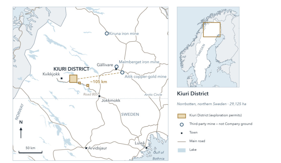
Location context
Location of the Kiuri District in Norrbotten, northern Sweden
The mines and deposits shown are third-party ground, named for location only and not indicative of any result at Kiuri.
Partner diligence
Request the full evaluation brief.
The full evaluation brief — tenure, drilling record, gold-evidence audit, gated programme and source register — is available to qualified counterparties under confidentiality.
Request evaluation brief